Updated Story: July 10, 10:30 a.m.
As forecasted, favourable weather conditions last night resulted in shifting winds that blew the fire back onto itself and away from the Canada/US border.
The United States has put considerable resources on the 3,200-acre fire.
For current information on the Hope fire, residents should consult US agency websites:
https://inciweb.wildfire.gov/incident-information/wanes-hope-fire
https://www.facebook.com/newfireinfo
https://www.facebook.com/stevenscountyem
The RDKB will continue to monitor the situation and post updates as needed on our website and social media channels.
Updated Story: July 9, 10:00a.m.
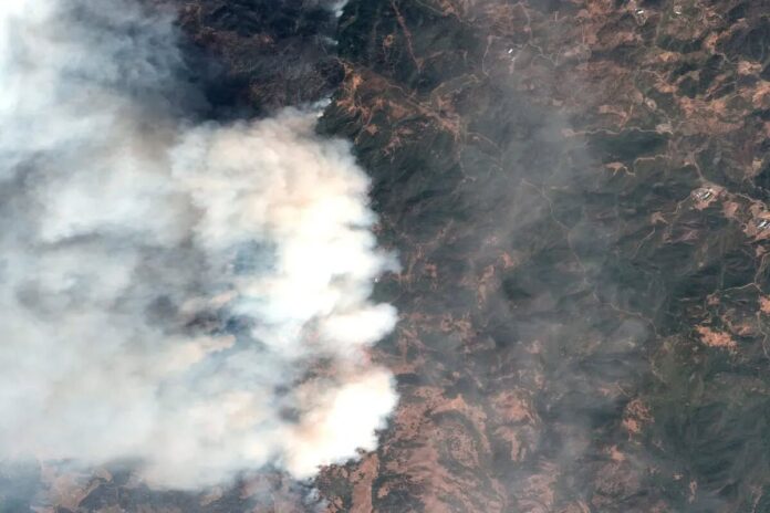
The Hope Wildfire in Washington, USA, has grown to 1,294 hectares (3,200 acres) as of Wednesday morning.
The blaze was identified on Tuesday, July 8, at around 1:15 p.m. It is burning south of Highway 3, between Christina Lake and Trail – about 19 km south of the Waneta border crossing.
It remains zero per cent contained.
The main fuels are grasses and shrubs. Strong winds on Tuesday afternoon caused the fire to spread north rapidly. Fire behaviour remained active overnight.
The U.S. Department of Natural Resources has response efforts underway, including five strike teams that arrived on scene overnight, according to a 9 a.m. update on the U.S. Fire Incident Information Portal website.
The BC Wildfire Service is also assisting, deploying air tankers on Tuesday evening.
The U.S. Department of Natural Resources says crews will be utilizing aerial resources today to bring the fire under control and slow its spread toward nearby structures.
“The primary focus today is public and firefighter safety.”
The forecast for the area shows little chance of showers or thunderstorms.
A cold front is expected to bring breezy southwest winds ranging from 24 to 32 km/h, with gusts reaching 40 km/h by 10 a.m.
Wednesday, becoming northwest between 1 p.m. and 7 p.m. with gusts anticipated to reach approximately 48 km/h.
While there is no threat to residents north of the border at this time, the Regional District of Kootenay Boundary activated its emergency operations centre to Level 1 on Tuesday evening as a precaution.
Updated Story: July 8, 7 p.m.
The Hope Wildfire is currently 15 kms south of the border. BC Wildfire Service continues to monitor & share air resources. Current weather forecasts predict a shift in wind direction tonight that will keep the fire away from the border.
A good way to ‘see’ where the smoke is coming from and what the smoke forecast is predicted to be is on: www.firesmoke.ca.
It can be quite surprising when you see how far smoke can travel.
Updated Story: July 8, 4:05 p.m.
The Regional District of Kootenay Boundary (RDKB) has activated its emergency operations centre to a level 1 to monitor the wildfire burning approximately 19 kms south of the US/Canada border.
Currently, there is no threat to RDKB residents. Smoke from the fire is visible in the Lower Columbia communities and Christina Lake.
The BC Wildfire Service is sending air tankers and US air support is en route to the fire.
“We are activating out of an abundance of caution and to continue to monitor the fire,” said Mark Stephens, EOC Director for the RDKB.
“With wildfire season here, we encourage residents to plan for emergencies, such as create Grab and Go kits.”
Residents are also reminded to sign up for the RDKB’s free emergency alert system and to plan for an emergency. Visit here for more info https://emergency.rdkb.com/
Stay Updated
Check the RDKB’s emergency management website and @RDKB_Emergency Twitter Feed for reliable updates: https://emergency.rdkb.com/
Monitor the BC Wildfire Service website for wildfire maps: https://wildfiresituation.nrs.gov.bc.ca/map
Make sure your journey is not affected by highway closures: https://www.drivebc.ca/
Original Story: July 8, 3:39 p.m.
Smoke from a wildfire burning 12 kms south of the US/Canada border near North Point is bringing smoke and ash into the Kootenays this afternoon.
The Regional District of Kootenay Boundary says there is currently no threat to residents and the situation is being monitored alongside the BC Wildfire Services.
We will have more information as it comes in.
Be the first to know! Don’t miss out on breaking news and daily updates in your area. Sign up to MyKootenayNow News Alerts.


